Of late trekking in Karnataka has been a bit of a pain in the ass. Some stray incidents of irresponsible trekkers, combined with some naxal activities in the Western Ghats and with a topping of heavy monsoons resulted in us not getting permission for most of our to-do list of treks. The initial 3 day plan was reduced to a single day trek to Tadiyandamol in southern Coorg district, which is the third tallest peak in Karnataka standing at 1748 MSL and the tallest one in Coorg district. But looks can be deceiving since even after having this distinction; it was a relatively easy trek.

 |
| Man Creates Thorns, Nature Creates Flowers |
Tadiyandamol literally means "the tallest one" in the local Kodagu language. Initial plan was to trek the peak, cover the palace nearby and finally Chelavara falls. And this we were gonna do in true blue spartan style, i.e. travelling in public transport all the way, hence resulting in the entire trip costing us just 950 bucks which was kinda shocking in today’s inflammatory times. The main advantage of travelling this way is that you interact with the locals a lot more and unlike some alien who is transported directly to the destination, sees it, enjoys it and returns back. We had booked an overnight bus to Virajpet, the nearest major town to the trek spot.

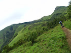
After close to an hours ride from Virajpet we got down at the starting point of the trek (Aramane stop or you can even say Tadiyandamol stop, people will understand) which is around 3-4 kms prior to Kakabe. From this starting point it is close to 8 kms to the peak (GPS reading). The initial part of the trek is via a tarred road and surprisingly the same road goes all the way to the peak without taking any diversions. So a guide is never required for this trek. But at one point trekkers might be confused, which is a Y fork they might encounter almost halfway, and at this point one has to take a left. The road goes through all the phases possible. Initial tarred road to kuccha jeep trail to kuccha bike trail and finally a trekking trail. The initial part of the road is dotted with numerous estates and resorts, primarily coffee and cardamom ones.


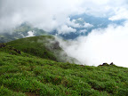
As we gained elevation the views started to get better, surrounded by absolute greenery and greeted every now and then by some cheerful mini waterfalls flowing across the trail. Soon enough we came across a clearing and we suddenly got the first clear view of the Tadiyandamol peak and the lesser dominant peaks flanking it, and this clearly was a “WOW!!!!” moment of the trek. The weather so far was quite pleasant and from this spot onwards the trail was going through grasslands. Since this was post monsoons we encountered some leeches (1-2 bites each), but much lesser than what we had actually anticipated.

 |
| @ Peak-With another gang from blore |


After spending close to an hour at the top, having our lunch, we started the descent at around 1pm. As expected the initial km was taxing on the legs. Reached back to the bus stop at around 3.30pm after a long walk. As soon as we reached the stop it started to rain cats and dogs, “WESTERN GHATS” style. Our plan was to take a bus to Chelavara falls(Cheyyandane stop) retracing the same route back to Virajpet and from there take a local auto till the falls. Soon enough the rains stopped and a bus arrived and we boarded it. The last bus to Virajpet leaves Kakabe at around 6.15pm, after which there are very less transportation options. So we had to visit the falls and return back before that.
 |
| Chelavara Falls |
.JPG) |
| Modeling for Cinthol-Alive is Awesome ad :P |
Got down at Cheyyandane town, had a wonderful lemon
tea at a stall nearby and took a 4 wheeler auto ;) to the falls which is around
3-4 kms from the main road. There is road right upto the falls. And within no
time we were into the freezing waters of this beautiful falls. Infact I found
this falls to be much better than the much hyped Abbey falls near Madikeri.
Finally we returned back to the main road and the last bus arrived at 7pm (delayed
ofcourse J
) and we reached back to Virajpet at around 7.30pm. Then it was time to find some good eatery/restaurant
and unfortunately we didn’t find one and had to content ourselves with some
crappy meal. Boarded the 10.15pm overnight Rajahamsa bus back to Bangalore, which
unfortunately was infested with bed bugs….!!!! The WTF moment L.
Anyway reached Bangalore early morning and spent the remainder of the day just
catching upon lost sleep over the last 2 nights.
Trek Details:
Trek Distance-> 17kms (GPS reading)
Total Cost Per Person -> 950
Snaps Link:
https://picasaweb.google.com/117615192470834757069/Tadiyandamol
https://picasaweb.google.com/104803450757964777769/TadiyandamolTrek#
 |
| The Group Snap |
Thats a nice writeup !!
ReplyDeleteYou mentioned "Did not get permissions"... Is there a checkpost for permission to trek to Thadiyandamol ?
Where is the checking done ?! Do we have to pay anything at the check post ?!
Is there a way to bypasss this check and still camp at the base of Thadiyandamol ?!
thnks...
Deletethis trek doesnt require any permission watsoever nor are there any checkposts... so no need for stealth mode :D
Hi Nithin,
ReplyDeleteExcellent pictures and write up. We (5 of us) are planning for this trek in September 2014. We plan to carry tents and sleeping bacgs to spend the night there. Do you have an idea if that is feasible and a good idea?
Most of us are first time trekkers and so we want to experience the "stay at the top" thing. Coudl we place tents and sleep there?
Any other tips on what type of shoes to carry etc?